|
Unique Features:
|
 |
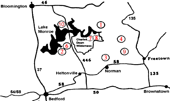
Charles
C. Deam Wilderness - Indiana's only Congressionally
designated wilderness area has 13,000 acres providing
for solitude and a remote experience. |
|
|
Pioneer
Mothers Memorial Forest - An 88 acre virgin
old-growth forest and archaeological site. The
Forest's only Research Natural Area. |
|
|
Hickory
Ridge Lookout Tower - Constructed by the CCC
in 1939. This historic tower is listed on the
National Historic Lookout Register. Located in Charles C. Deam Wilderness. |
|
|
Hemlock
Cliffs - a box-shaped canyon with sandstone
formations, seasonal water falls and rock shelters |
|
|
Rickenbaugh
House - A stone house built in 1874, used
as a local post office and church meeting house.
Now on the National Register of Historic Places. |
|
|
Wesley
Chapel Gulf - This National Natural Landmark
is an 8 acre collapsed sinkhole with an alluvial
floor which provides a window to the underground
river system. |
|
Land
Recreation:
Over
200 miles of hiking, horseback, and mountain bike trails.
Hunting, nature study, camping, picnicking and scenic drives
are all available at Hoosier N.F. Campgrounds are located
adjacent to large lakes and in conjunction with some of the
trail systems. Five horse camps are available associated with
equestrian trails.
Water Recreation:
Hardin Ridge Recreation
Area is popular with boaters and anglers alike because of
easy access to Lake Monroe. Other recreation areas are located
on Celina Lake, Indian Lake, and Tipsaw Lake. The Little Blue
and Lost River offer opportunities for seasonal float trips
through the Forest.
Panfish,
catfish, and bass fishing opportunities are available throughout
the Forest. Mano Point provides boat access to the Ohio River.
Click
for the Hoosier
National Forest's Website
Click for the USDA
Forest Service Website |


 This is a favorite
resource in Indiana. The rules at Hoosier National Forest
are minimal. This adds greatly to the charm of the place,
but also means you need to be tolerant and mindful of other
people's pursuits. Hunting is allowed at Hoosier National
Forest, so be safe.
This is a favorite
resource in Indiana. The rules at Hoosier National Forest
are minimal. This adds greatly to the charm of the place,
but also means you need to be tolerant and mindful of other
people's pursuits. Hunting is allowed at Hoosier National
Forest, so be safe.