Knobstone
Trail in Indiana
 The rugged
terrain of this 58 mile backcountry hiking trail is often compared
to the Appalachian Trail (AT), and many people use it to train
for the AT. The Indiana
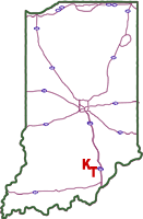
Department of Natural Resources manages the Knobstone Trail (KT)
in Clark, Scott, and Washington counties in southern Indiana.
It is Indiana's longest footpath, passing through Clark State
Forest, Elk Creek Public Fishing Area, and Jackson-Washington
State Forest. These state resource properties contain nearly 40,000
acres of rugged, forested land. The trail presently extends from
near Deam Lake, just north of SR 60 in Clark County, to Delaney
Park, just east of SR 135 in Washington County.
The rugged
terrain of this 58 mile backcountry hiking trail is often compared
to the Appalachian Trail (AT), and many people use it to train
for the AT. The Indiana
Department of Natural Resources manages the Knobstone Trail (KT)
in Clark, Scott, and Washington counties in southern Indiana.
It is Indiana's longest footpath, passing through Clark State
Forest, Elk Creek Public Fishing Area, and Jackson-Washington
State Forest. These state resource properties contain nearly 40,000
acres of rugged, forested land. The trail presently extends from
near Deam Lake, just north of SR 60 in Clark County, to Delaney
Park, just east of SR 135 in Washington County.
clickable
image map of Knobstone Trail
Map of Northern Section of Knobstone Trail (11 MB PDF file)
Map of Southern Section of Knobstone Trail (10 MB PDF file)
Caution
Because the
trail follows the Knobstone Escarpment, there are many steep climbs
and descents. It can be regarded as a rugged, difficult trail
to hike. It is managed and maintained at backcountry standards,
and structures are limited to primitive steps and waterbars. Maintenance
responsibilities fall to a two-person field crew, occasionally
assisted by volunteers.
The trail crosses
several roads, varying from state highways to gravel country lanes.
Use caution when crossing these roads.
Trailheads
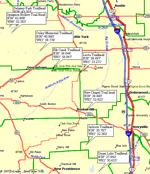
Seven trailheads
have been developed along the trail, providing parking areas and
direct access to the Knobstone Trail. The Delaney Park Trailhead
is located within Delaney Park, a Washington County Park that
includes facilities for camping, cabins, showers, and a gated
entrance. The Elk Creek Trailhead is located at a public access
site on Elk Creek Lake. The parking area for the lake and trail
is paved. All of the other trailheads include a small gravel parking
area.
Following
the Trail
The Knobstone
Trail map shows the general route of the trail and the topography
of the area. Minor reroutes have been constructed over the past
few years to avoid some problem areas, and they are not indicated
on the map. On the ground, the trail is marked by 2-inch by 6-inch
white blazes painted near eye level on trees. Two blazes on a
tree indicate the trail changes direction at an intersection with
another trail or forest road. Attempts are made to mark the trail
so that it is easy to follow. Trees which fall on the trail because
of natural events can make it more challenging. Therefore, it
is important to utilize both the map and the blazes while hiking
the trail.
While using
the trail, please be sure to stay on public property. In some
areas, the trail follows a very narrow corridor of public property.
The KT map shows the public property boundaries. Hikers are responsible
for helping maintain good relations between hikers and private
property owners.
The trail map
is available from DNR Map Sales (317-232-4180). They are usually
available at Clark State Forest's office (812-294-4306) in Henryville,
Jackson-Washington State Forest's office (812-358-2160) near Brownstown,
the Deam Lake State Recreation Area's (812-246-5421) office near
Borden, and the Delaney Park gatehouse (812-883-5101). The maps
are available from the properties only during office hours.
Trail
Terrain
The trail traverses
land with extreme relief distinguished by narrow, relatively flat-topped
ridges typical of the Knobstone Escarpment-a knobby slope between
the Norman Upland and Scottsburg Lowland, two of southern Indiana's
natural land regions. The Knobstone Escarpment is one of Indiana's
most scenic areas, rising more than 300 feet above low-lying farmland
in some areas as it snakes northward from near the Ohio River
to just south of Martinsville. A central upland, mixed hardwood
forest (oak-hickory and beech-maple associations) dominates much
of the escarpment. "Knobstone" shale, which is actually
a combination of weathered brown shale, sandstone, and siltstone,
is common in the area and gives the escarpment its name.
Allowed
Uses
The Knobstone
Trail is developed and managed for foot traffic only. Because
of erosion, damage to structures, and the safety of hikers, horses,
bicycles, and motorized vehicles are not allowed on the trail.
Camping
Along the Trail
Primitive,
backpack camping is allowed along the trail only on public lands
(marked on the map) at least one mile, by trail, away from all
roads, recreation areas, and trailheads, and out of site from
the trail and all lakes. There are no designated campsites. Although
it is not required, overnight trail users should consider registering
at one of the nearby property offices: Jackson-Washington State
Forest (812-358-2160) office is located about 3 miles southeast
of Brownstown, north of SR 250. Starve Hollow State Recreation
Area (812-358-3464) office is located east of SR 135 approximately
6 miles south of Brownstown and 17 miles north of Salem. Clark
State Forest (812-294-4306) office is located west of US 31, 10
miles south of Scottsburg and 1 mile north of Henryville. Deam
Lake State Recreation Area (812-246-5421) gatehouse is located
north of SR 60, adjacent to Clark State Forest, 1 1/4 mile west
of Deam Lake Trailhead. Delaney Park (812-883-5101) gatehouse
is located 9 miles north of Salem and 2 miles east of SR 135.
Campgrounds
are located at Delaney Park (812-883-5101), Clark State Forest
(812-294-4306), and Deam Lake State Recreation Area (812-246-5421).
Deam Lake SRA
1217 Deam Lake Rd
Borden, IN 47106
Online camping reservations available
Disposing
of Wastes
Everything
carried in on the trail is to be carried out. Organic wastes are
to be buried in a 4 to 8-inch hole, at least 200 feet from the
trail, water, and dry gullies. Either carry out toilet paper in
a plastic bag or bury it deeply so it is not dug up or left in
the open. Please respect these regulations, or camping may be
prohibited in many areas.
Protect
The Water Supply
Always wash
your dishes or yourself a few feet away from the edge of a lake
or stream. This way the soil acts as a filter, preventing soap
suds and scraps of food from polluting the water. After washing
your dishes, rinse them a safe distance from the bank. A few feet
can make a big difference. Sources of water in many areas are
often limited and can fail during dry periods-plan ahead! Remember
to treat your drinking and cooking water by boiling for several
minutes or with a commercial water filter.
Drinking
Water
During much
of the year, water is unavailable from most of the streams near
the trail. Hikers need to provide their own water supply. To avoid
carrying an entire trips' supply of water, water containers can
be cached at trailheads or access roads. Be aware that there are outfitters to help with this. If water is used from
streams, ponds, or lakes, be sure to treat it properly by filtering
or boiling.
Use
of Fires
To reduce the
possibility of a forest fire, use a portable backpack stove rather
than a campfire for cooking. A portable stove cooks your meal
long before a fire is ready. It also helps prevent fire-blackened
rocks in areas where people camp.
Campfires are
allowed except when forest fire conditions are high. Extreme caution
should be taken at all times: scrape the area down to bare soil,
keep the fire contained in the bare soil area; completely extinguish
it; and return the site to its original condition. Use only dead
and down wood, and do not stockpile wood. While this was once
considered a friendly gesture in remote areas, today it is one
more thing which reduces the spirit of solitude and independence
which people seek.
Any campfire
in a backcountry area should be in a pit 12 inches or less in
diameter, and a three-foot diameter area should be cleared to
mineral soil around the fire. Prior to leaving an area where a
campfire was built, mix ashes with the soil, fill the pit, and
cover the cleared area with the humus layer which was originally
removed.
Other
Trail Tips
Wearing bright
colors during hunting season, particularly deer season, is a good
idea. In fact, it may prevent injury or death. However, during
other times of the year, bright reds, oranges and yellows serve
to actually "shrink" the outdoors by visually intruding
into the wide spaces and solitude which are part of the outdoor
experience. When drab colors (browns, blues, and greens) are used
for clothing and tents, individuals are visible at less distance,
and more people can use the same general area without knowing
of each other's presence.
Most of us
love "man's best friend," but even on a leash a pet's
presence may disturb the outdoor experience. Native wildlife often
shies away from areas which dogs use, thus preventing the close
observation many hikers desire. Barking also often disturbs other
hikers, and sanitation within camping zones can become a problem.
Therefore, it is recommended that pets not accompany hikers on
the Knobstone Trail.
Before starting
out, study maps of the area and learn the terrain. Be sure you
are familiar with all the options of time, alternate routes, and
weather. Do not forget the shorter daylight hours during late
fall and winter. Be sure to travel with a first aid kit, map and
compass, and know how to use them.
State
Forests
The Knobstone
Trail passes primarily through state forests, which are managed
for "multiple use" to obtain maximum benefits from recreation,
timber, and wildlife production and watershed protection. They
are open to the public for hunting during season, and are actively
managed to increase the fish and wildlife population. Trails are
developed, along with other recreational projects, to be compatible
with the growth and harvest of timber and to retain the watershed
protection that forests naturally provide. The harvesting of timber
provides valuable income for the state of Indiana. Timber management
and harvesting also provide diverse cover and food necessary for
the perpetuation of many game and non-game animal species and
helps insure that our forest resources will be available for future
generations.
Trail
Extension
There is work
underway to extend the Knobstone Trail, developing northward to
connect with Hoosier National Forest, Yellowwood State Forest,
and Morgan-Monroe State Forest. Built with the help of the Hoosier
Hikers Council, the 42 mile Tecumseh Trail is meant to be
the northern section of the Knobstone Trail. Work is currently
being done on the middle section that will connect up to create
a 140 mile long Knobstone Trail.