|
|

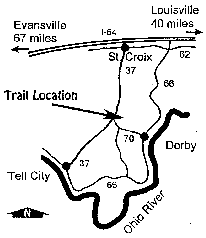
| Mogan Ridge West offers approximately 12.3 miles of multiple-use trails. Enjoy hiking, horse riding or mountain biking through scenic hardwood forests. The trail connects with Mogan Ridge East on its east end, a little north of Talley Cemetery. Horse riders and mountain bikers are required to have a trail permit and stay on trails designated for their use. Annual ($35/year) and day-use ($5/day) permits are available from Hoosier National Forest offices and several local vendors. This trail is operated by: |
 |
|
Mogan
Ridge West Mountain Biking Trail Info
|
|
| Directions: |
There are several places to start, so check out the detailed and interactive maps above. |
| Length: | Approx. 12.3 miles |
| Trail Type: | Single track & fire roads |
| Skill Level: | Intermediate |
| Trail Description: |
The trail is pretty moderate, with a few tough climbs. There are two singletrack sections (some fairly technical) with a gravel road in between. Riding counter-clockwise offers the best descents. |
|
YIELDING
THE RIGHT OF WAY
|
|
| Since you may be sharing the trails with different types of users, please observe the following trail courtesy: | |
|
-
|
Mountain bikers yield to horse riders and hikers. (Make your approach known well in advance.) |
|
-
|
Hikers yield to horse riders. |
|
-
|
Horse riders: control your horse. |
|
||||||||||||||||||||||||||||||||||
 |
||||||||||||||||||||||||||||||||||