This trail operated by: |
 Birdseye
Trail is an approximately 11.8 mile long multiple-use trail allowing
hiking, horseback riding and mountain biking. It's shaded trails go
through a variety of terrain in scenic hardwood forest.
Birdseye
Trail is an approximately 11.8 mile long multiple-use trail allowing
hiking, horseback riding and mountain biking. It's shaded trails go
through a variety of terrain in scenic hardwood forest.|
FACILITIES
|
|
|
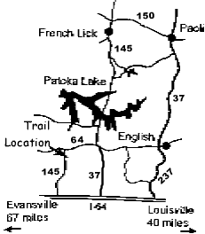
Day use parking is available with one large parking area to the north, and a smaller spot on the west side. (See map to Birdseye Trail.) From State Rd 145 turn east onto Birdseye Loop Road. Turn east into the small parking area after 1.5 miles. This parking area is little more then a widened fire road with a gate marking the trailhead. Another new and much larger parking area may be reached from the Town of Birdseye. Turn right on the road that runs along the south side of the railroad tracks in town. At the T, turn right. Parking is about 0.25 miles, on the right (watch for trail crossing signs). |
| USE
FEES |
|
| Horse riders and mountain bikers are required to have a trail permit and stay on trails designated for their use. Annual ($35/year) and day-use ($5/day) permits are available from Hoosier National Forest offices and several local vendors. |
|
MOUNTAIN BIKING INFO |
|
| Directions: | From I-64 (approx. 40 miles west of Louisville), take Hwy 145 North approx. 6 miles to Birdseye. Turn right (east) onto the gravel road that is south of the railroad tracks and follow it approx. 1 mile. Then turn right (south) at the T intersection onto the road with a gate. Park and start at the gate. (Check out the maps above too.) |
| Length: | Approx. 11.8 miles |
| Trail Type: | Single track & fire roads |
| Skill Level: | Beginner to Intermediate |
| Description: | The trail consists of 2 linked loops: a 6 mile fire road loop that is better for beginners, and a 6 mile single track loop (marked by small blue arrows) that is more challenging. As the trail winds through hardwood forest, pine forest, and meadows, there are some steep, technical climbs, some rocky sections, a stream crossing, and long, rolling hills. Along the way are a lake, creeks, old homesteads and a cemetery. Dense brush can offer an added challenge when trail gets overgrown in the summer months. Also, watch out for wildlife (and hunters during hunting season). |
| YIELDING
THE RIGHT OF WAY |
|
| Since you may be sharing the trails with different types of users, please observe the following trail courtesy: | |
| - |
Mountain bikers yield to horse riders and hikers. (Make your approach known well in advance.) |
| - |
Hikers yield to horse riders. |
| - |
Horse riders: control your horse. |


|