www.IndianaOutfitters.com - Indiana's Online Outdoor Recreation Guide
Home
Outdoor Resources:
Rivers & Streams
Indiana State Parks & Reservoirs
Hoosier Natl Forest
Knobstone Trail
Indiana Dunes
National Park
Mountain Biking


Hoosier National Forest in Indiana
Southern Section
(from I-64 to the Ohio River)

MAP KEY
TRAIL NAME
TRAIL USE TYPE
APPROX. MILES
1 Celina Interpretive Trail Hike 1
2 German Ridge Trail Multiple Use 23
3 German Ridge Lake Trail Hike 1.5
4 Mogan Ridge West Trail Multiple Use 12.3
5 Mogan Ridge East Trail Hike 6.6
6 Oriole East Trail Multiple Use 8.8
7 Saddle Lake Trail Hike 2.2
8 Tipsaw Lake Trail Hike/Bike 5.9
9 Oriole West Trail Multiple Use 7.2
10 Two Lakes Loop Trail Hike 16
11 Buzzard Roost Trail Hike 0.8

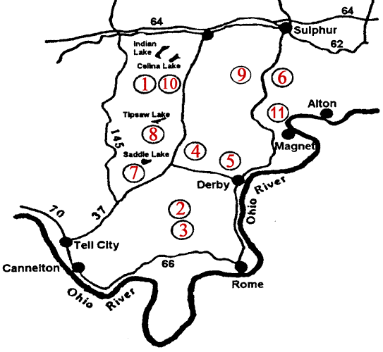
clickable image map of Southern Section of Hoosier National Forest:

German Ridge Lake Trail Celina Interpretive Trail Two Lakes Loop Trail Oriole West Trail Tipsaw Lake Trail Saddle Lake Trail Oriole East Trail Mogan Ridge East Trail Mogan Ridge West Trail German Ridge Trail Buzzard Roost Trail

ETIQUETTE AND RULES
Horse riders and mountain bikers are required to have a trail permit and stay on trails designated for their use. Annual ($35) and day-use ($5/day) permits are available from our offices and several local vendors.
Camping is permitted in back-country areas. Motorized travel on trails is not permitted. Please pack out your trash and leave no trace of your visit.

SAFETY
Be aware of hunting seasons. Blaze orange clothing is recommended during deer season. (Do not wear white.)
Park your vehicle off the roadway if a parking lot is not available where you wish to access.
Many trails intersect roadways. If you choose to use a road as part of your trip, be mindful of traffic.